Monday, May 31, 2010

May 31 - Zoar

Starting Weather: Hazy Sunny, 81°
Ending Weather: Light Rain, 80°
Distance Covered:  .79 miles
Time: 2:58 PM - 4:03 PM
When we left Zoarville, we discussed stopping somewhere else on our way home.  We decided to stop at the very next trailhead, which was Canal Lands park in Zoar.  We like it here, because we were here on January 1, and were so taken by the bridge and wooden stairs that lead down to the trail,  It looked very lush today since it had just rained.  We found a nest in the bridge and could hear birds in the trees, whose tops were near the top of the bridge.  A man on the trail told me he had seen two pleated woodpeckers while biking on the trail that day.  We listened for them and could hear them, but no sightings.  Ironic that someone flying by on a bicycle sees two woodpeckers and we slowly creep around and watch intently and nothing!
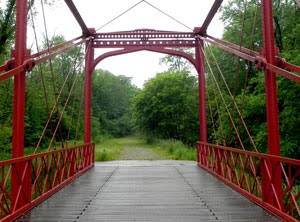
May 31 - Zoarville to Dover Dam

Starting Weather: Rainy, 72°
Ending Weather: Partly Sunny, 80°
Distance Covered:  4.28 miles on bike, .36 mile on foot
Time: 10:58 AM - 2:35 PM
Today was a day of exploration. We drove to Zoarville, where the beautiful Fink Truss Bridge is located. My plan was to ride the trail on my bike to the Dover Dam. It was kind of stormy when we got there, but not really raining much.  My plan was to ride my bike to the Dover Dam, about two miles each way.  Kay was going to stay behind and take photos near the bridge.  When I was over halfway to the damn, Kay called and told me that the sky looked really black and I should turn around.  The problem was that even once I arrived at the damn, there was no shelter, nor was there any access to the road.  Even if I had made it to the dam, if it had been storming, I'd have been stranded.  So I turned around.   We went back to the car for awhile, and drove south on Route 8000 to see if there was a trailhead anywhere near the road.  We could not find one,, even though it appeared on the map that the trail went right up to Route 416 off 800.  We turned around and drove back to Zoarville. The sky had started clearing by now, so I rode my back all the way to the dam.  It was a pretty area with pine trees and tulips trees. there was a walkway that led to the dam from the trail, and it was elevated above the trees, so that I was eye level with the tops of the trees.   It looked like the trail continued, but I didn't want to venture any further, as we could not find where the trail went from here or where it lead to any roads.   I turned around and rode back to where Kay was.

Sunday, May 30, 2010

May 30 - Center Road

Starting Weather: Sunny, 86°
Ending Weather:  Sunny, 84°
Distance Covered:  1.47 miles
Time: 5:30 PM - 7:10 PM
Today was very hot, so we did not plan a long hike.  We had looked at some photos of flowers and insects  from the Cuyahoga Valley Photo-graphic Society and became inspired.  We went to Center Road and walked north.   There just wasn't a whole lot going on today; maybe it was because of the heat.  Kay found a snapping turtle in a creek, but he refused to show anything more than the tip of his nose.  Near the car on the way back, we heard a bird singing "minnie driver, minnie driver." - Kay thought it sounded more like "chitty bang bang." - but we never saw the bird.  Oh well, not every day is an inspiration!

May 29 - Beaver Marsh


Starting Weather: Sunny, 82°
Ending Weather:  Clear, 78°
Distance Covered:  1.29 miles
Time: 6:46 PM - 10:50 PM
Another adventure.  We got the idea that we should go back home by way of Riverview Road, so we could stop at the Beaver Marsh and catch the sunset, the moonrise, the beaver, and possibly some other nocturnal animals.  We did witness a beautiful sunset, and Kay stalked the beaver for a bit, getting a few good shots.  After that, things fell apart.  I got online on my phone to see what time the moon would rise.  It said 10:14 PM.  My phone battery was running low, so I went by the first site that came up, which was somewhere in New Hampshire.  After waiting until almost 11:00 for the moon, long after every other human being had left the boardwalk, we decided that we'd go back to the car, charge our phones, and try to figure out exactly where the moon was.  Kay had a headlamp that she wore to illuminate the trail.  Just as we turned right to go to the parking lot, we saw a vehicle turn into the lot from Riverview Road.  We both initially thought it was a park ranger or police officer, until we realized the vehicle had a headlight out.  Things then seemed to become a whole lot more sinister.  It was a man in an old van.  You've never seen two "mature" women run so fast- both carrying cameras and tripods - get in the car, stash the gear and peal out of the parking lot!   We saw the moon somewhere over Akron on the way home.
Note to self:  Need to bone up on geography; not exactly close to New Hampshire.
Another note to self:  Stop watching all those Criminal Minds reruns.

May 29 - Bacci Park


Starting Weather: Sunny, 82°
Ending Weather:  Sunny, 84°
Distance Covered:  3.89 miles
Time: 12:42 PM - 5:23 PM
The first part of today's outing was a trip to Louis Bacci Park in Cuyahoga Heights.  We had last been here in January, when everything was white: white sky, white bridges, white ground, white canal.  Today was a different story.  The sky was blue, the ground was covered with vegetation and lots and lots of wildflowers, the canal was murky green, but teaming with wildlife.  The two footbridges that are part of the trail were still white, but that's OK.  They look great like that when everything is in color!  I walked south part the I-480 bridges and almost to Rockside.  When I got back, we decided to walk north for awhile.  It was still warm, but there was some shade and a breeze.  We sat on a bench near one of the locks for a few minutes - so peaceful.  We will return to this area in the fall to see yet more color.

Friday, May 28, 2010

May 28 - Brecksville

Starting Weather: Sunny, 80°
Ending Weather: Sunny, 83°
Distance Covered: 2.49 miles
Time: 12:20-2:20 PM
We drove to the Brecksville Reservation, Station Road trailhead, and immediately set out to stalk the Bald Eagles.  As we were walking towards our usual nest-viewing spot, we looked over and saw one of the adults perched in a dead tree.  Kay let me use her tripod to take a few shots first.  She then took several shots also.  We then headed farther up the trail to observe the nest.  The eaglets are getting very big, and are flapping their wings and trying to fly.  They almost seem to be ready to jump (or fall!) out of the nest.  As I was looking at them, I thought about how precious they are and how they are given more reverence that some human beings.
Today was quite hot and sunny, so we did not stay long.  I took a few more photos of one of the adult eagles, who was perched even closer to the trail, on the way back to the car.

May 28 - Beaver Marsh


Starting Weather: Clear, 65°
Ending Weather:  Sunny, 75°
Distance Covered:  1.47 miles
Time: 6:05 AM - 10:27 AM
We just can't seem to beat the sunrise!  We left  the house at 5:15 a.m., but it was light out by the time we arrived at the Beaver Marsh.  It was still beautiful, though, with the mist rising off the water, and the sun shining through the trees.    We saw a beaver getting ready for bed, and a wood duck mama with her 6 ducklings.  Kay spotted a new robin's nest with the robin in residence.  No babies visible yet.  Kay decided to stay in the area and take photos, while I walked north towards Deep Lock Quarry.  She picked me up on Riverview near a path that led out from the trail, about a mile south of Route 303 and about a third of a mile south of the Deep Lock parking lot.  We went to the Winking Lizard for lunch before heading off to Brecksville.

Thursday, May 27, 2010

May 27 - Canal Fulton

This evening, after having supper at Luigi's in Akron with Jim, Bill and Tim, we went to Canal Fulton for an ice cream cone.  Of course, we took our cameras. The place we go for ice cream in Canal Fulton, Cherry Street Creamery, is right on the trail.  Canal Fulton is so pretty that we always get very picturesque shots.  We didn't stay long, but roamed around the very busy park area here and took a few photos while we ate our cones.

May 27 - Rollin' on the River!

Route 21 Bridges
Merganser

Starting Weather: Mostly Sunny, 79°
Ending Weather:  Partly Cloudy, 86°
Distance Covered:  5.6 miles in a canoe
Time: 11:30 AM - 3:00 PM
It's my birthday!  Kay agreed to rent a canoe and row down the Tuscarawas River in Massillon.  It flows very near the towpath here, so we were able to view the towpath from the river.  It was a hot and sunny day, but we were able to find many shady spots to pull the canoe into.  We didn't see a great quantity of wildlife, but did see a merganser duck, some mallards with a single duckling (who flew away when they detected us, leaving the duckling to fend for itself.)  We also saw and photographed a bird in a tree, which we later learned was an Eastern Kingbird.  The GPS on my phone was malfunctioning, but we were so familiar with the trail here that most of the time we could tell where we were.  We passed under the bridge at Highmill, and then the Route 21 bridge, one of our favorites.   I got our at Route 21 to take pictures of Kay in the boat.  I decided to stay out and race her to the finish.  We tied.  It was a fun day, and another different perspective on the trail.

Wednesday, May 26, 2010

May 26 - Forty Corners and Lake Street


My day on the trail started much earlier than planned, as a result of a salon mix-up.  Anyway, I went to Forty Corners trailhead and walked northwest.  I hadn't been here for a few weeks, and it was certainly much, much greener than last time.  Although I heard quite a few birds singing, I didn't see many.  And Kay - the bird photography and attraction expert - was not with me.   I did get a shot of a grackle and of a catbird with its feathers ruffled,  but decided to focus more on trees and flowers.  It was almost 80 degrees, but this part of the trail is fairly shady, so it wasn't too bad.  I went back to my car and decided to drive to Lake Street.  There is very little shade here, so I did not walk as far.  I did get some nice "puffy cloud" photos.  I also took a lot of photos to compare to photos taken here in earlier months.  I don't think summer is going to be our favorite hiking season!

Tuesday, May 25, 2010

May 25 - Crystal Springs


This was an early evening hike. We planned to dine at a restaurant across the street from the Crystal Springs trailhead, so we went there for a short walk. This is an area that often yields lots of bird sounds and sightings. Today we saw something brand new - a tiger swallowtail butterfly. We also heard and saw several catbirds. I spotted some turtles swimming, and as we were about to cross the foot bridge leading back to the parking lot, Kay spotted a bullfrog sitting on a branch in the canal. Another example of the constant novelty and excitement of each and every hike!

May 25 - Manchester Road

After seeing a photo in the Beacon Journal of a swan and her cygnets, we decided to go to Manchester Road and walk north towards Summit Lake.  We had seen a swan in the canal here a couple months ago, so were now  on a mission to see baby swans.  This is a surprisingly beautiful section of trail, which includes the point of the highest elevation of the trail.  Almost immediately we saw a Mallard couple under a bridge, watching their youngsters swim around about a hundred feet down the canal.  That was the first time we had seen Mallards with young who were not hovering over them.  We saw several more families as we walked, both Mallards and Canada Geese.   The geese were in various stages of development.  We also saw some barn swallows and rock doves (pigeons) tending to their nests in the rafters of the Waterloo Road bridge.  
Wildflowers still abound, and although we have seen wild yellow irises everywhere on the trail, today we saw some very pretty purple irises. We also saw a baby snapping turtle on the trail. It was tiny compared to an adult turtle!  
Baby Snapping Turtle on the trail
There are some heron's nests off to the west, and we saw a few herons flying by.  At Wilbeth Road, we stopped for a breather.  There were about 50 Canada geese walking towards the canal from a meadow on the other side.  Kay kept walking toward Summit Lake, and I went back to get the car and meet here there.  I took a few more photos of the floating boardwalk over the lake from above on Kenmore Blvd.

May 24 - Beaver Marsh

White-tailed Deer
American Beaver
Today must be mammal day.  As I approached the trail from the Ira Road parking lot, there was a doe, standing right on the towpath.  When she saw me, instead of running away, she actually ran towards me.  Of course, I just stood there, snapping away.  She finally turned tail and ran off, but I got a very good look at her.  We walked back to the Beaver Marsh and kept walking to the area where there is a panoramic view of the Cuyahoga River.  This is the spot where the robin's nest had been.  The nest was still there but it was empty!  We walked back to the boardwalk and over to an area where we had seen some rails, snakes and bullfrogs.  Kay yelled out suddenly; there was a beaver about two feet away from her to the side of the boardwalk.  he was too fast for us this time, but we planted ourselves in the same spot - with me almost losing my camera battery and monopod to the marsh in the process.  The beaver was kind enough to make an encore appearance, and then swam over the a bank where he dined on some plants.  Just about this time, a group from the Boys and Girls Clubs walked over, and they got to see the beaver chowing down as well.  As usual, the Beaver Marsh does not disappoint.

May 24 - Boston Mills

Gray Squirrel
Eastern Bluebird
The second leg of our trip consisted of an interlude at Boston Mills.  This seems to be an area that gets a lot of human traffic that the critters don't seem to mind.  There was a pair of bluebirds taking turns building a nest in a cavity in a stump, right in a small patch of land in the middle of the parking lot.  We also had a squirrel performing for us.  There is a great view of the Cuyahoga River here, as well as of the bridges just to the south.
This area will always remind me of the scout hike in 1999, when we rested on the benches outside the Boston Store.

May 24 - Peninsula

Cow Parsnip
We started off the day in beautiful Peninsula.  Again, this is an area that has certainly changed with the seasons.   Something I'd never noticed before that was quite plentiful along the trail was a large plant thta looked like a cross between Queen Ann's Lace and broccoli.  I found out later it is called cow parsnip.  It made me realize that the vast majority of my hiking has taken place in the fall, so there may be many plants and animals on the trail I have never seen before.  
One of the most striking changes is the number of people using the trail.  Walkers, joggers and bicyclists everywhere.  The deep blue skies dotted with fluffy clouds added to the splendor of the day.  I walked from Peninsula to Boston Mills Road.  Kay drove to Boston Mills and walked south.  We met up just south of the two bridges (I-271 and I-80)  The bridges that were totally visible for a great distance last winter are now framed in greenery.

Sunday, May 23, 2010

May 23 - Three strikes, we're out?

Kay being coy
Why is it we continue to have these little "brushes with the law?"  Tonight we were at the Towpath Avenue trailhead, trying to glimpse some nocturnal animals.  We weren't having any luck, and Kay's BRAND NEW tripod broke.  Suddenly we saw headlights.  I yelled to Kay to come back to the car.  It was a park ranger, telling us he was closing the gates, and we'd have to move our car.  He said we could come back in and take photos if we wanted.  We decided to leave and try the Lake Street trailhead.  We realized that we weren't getting anywhere, so decided to stop a couple more places and then head home.

May 23 - Ridin' the Rails!

Today we rode the Cuyahoga Valley Scenic Railroad, which runs along the Towpath Trail much of the way.  Jim came with us, and we boarded at the North Akron station.We took the round-trip excursion through the park.  It was a beautiful day, and such fun to see the trail from a different perspective.  We started off trying to take pictures through the (dirty) windows, but I decided to get up and go check out the opening above the door nearest our car.  The staff not only didn't chase us, they asked if they were in my way.  It wasn't the most relaxing way to go, but the views were far better.  We rode right by the eagles' nest in Brecksville and got much closer than we ever could have on foot, because of the restrictions.   We plan to ride the train again, in October and December.

May 22 - Warmington Road

Ebony Jewelwing Damselfly
Our next stop was John Glenn Grove on Warmington Road in Massillon. Here I was attacked by a butterfly, and we spotted a pair of Indigo Buntings, correctly identified by Kay, who had never seen one before in her life. We also saw some cedar waxwings frolicking through the trees. The lushness of the section of trail was phenomenal, and it almost obscured areas of the canal that we had enjoyed seeing on past outings. We photographed a beautiful black dragonfly, who was willing to pose for us.

Update, September 9, 2010:  Now that we know a little bit more about identifying insects, we know that what we saw was not actually a dragonfly, but a damselfly!

May 22 - Fort Laurens

We decided to drive north on America's Byway. Our next stop was Fort Laurens in Bolivar. Although the rain had stopped in Zoar, it must have moved north, because it was starting to get darker here. We went out anyway, and walked to the bridge over I-77. As the skies grew ever more threatening, I began to plan our escape route. I didn't want to go back to the car, because I wanted to look around a bit on the other side of the bridge. I decided that if it started to rain, we could run across the bridge and go down the embankment, allowing us to find shelter underneath the bridge. As it turned out, the skies were not bluffing It began to rain quite heavily. I was on the east side of the bridge, and I yelled to Kay, who was on the east side of the bridge, just snapping away with her camera, catching images of dark storm clouds. Kay came running towards me with all her heavy gear. We went down the side of the hill and under the bridge, where we waited out the downpour. We looked like a couple of drowned rats. I'd had time to shove my camera into my fanny pack, but Kay's gear was just too extensive to stash. She found a poncho while we were under the bridge and covered her cameras. When the rain had mostly subsided, we worked our way back to the car.

May 22 - Zoar


Today was a three-part trip. We started off at Zoar, at Canal Lands Park. Lucky for us, the rain had begun as we were pulling into the parking lot. We waited for about fifteen minutes until the rain subsided. As we were getting our gear ready to go out on the trail. a young woman and an Italian Greyhound came running from the trail to the parking lot. They had been caught in the rain and were soaked. We gave them some paper towels, and set out to explore the very wet, very green trail. The differences from our fist time here in January were stunning, but even since we had been here in March, it was so completely different. The bridge that we could see for quite awhile as we approached it, was not nearly obscured by greenery until we were almost on top of it. We climbed the stairs to the bridge, from where we could look down on the puddle-riddled trail below. We heard and then saw a Baltimore Oriole singing in a sycamore tree above the bridge.

Saturday, May 22, 2010

May 21 - Manchester Road


Today we went to the trailhead on Manchester Road that is just south of Nesmith Lake.  Our mission was to check on the ducklings and goslings Kay had seen there several days ago.  We saw them all, and they were getting much bigger.  Right away we saw four geese and a large group of goslings, who were very active.  On the grass, Kay spotted a mallard and her ducklings, huddled together.  When the ducks finally ventured into the water, we noticed that the geese were bullying them.   The ducklings were so cute, with very distinct markings and tiny wings that they tried to flap.  Maybe we've seen enough ducks and geese for the time being.

Thursday, May 20, 2010

May 20 - Canal Fulton


Today after work, I met Kay at Best Buy, so we could return her tripod. It was a good brand, but apparently, not meant for the heavy duty work that she does with her 500 mm lens. They took it back without incident, and we actually found and purchased another one that we thought would work much better for her. Afterward, we had dinner at the Strip. We then decided to go to Canal Fulton. This is an area that is always scenic, with its canal boats, bridges, quaint and colorful buildings and beautiful trees. Canal Fulton was bustling tonight. There were two ball games about to begin in the park, there was a band playing at one of the restaurants along the canal, and walkers, joggers and bike riders were plentiful.

May 19 - Under Route 21


Today my work day ended at the Massillon site. When I left work, I headed to Towpath Avenue, off Erie. At the trailhead, you can walk down under Route 21. The bridges look different in various types of weather, and today there were some distinct clouds in the blue sky. There were joggers and bicyclers along the trail, enjoying the beautiful weather.
After I left that area, I drove to Lock 4 park, to check on the mourning dove nest we had seen a couple weeks ago. To my chagrin, the nest was gone from the tree in which we had seen it, with the mourning dove atop it. This site is always very beautiful and scenic, so I took lots of photos while I was there.

Sunday, May 16, 2010

May 16 - Vanderhoof to Eastern


Well, we had yet another brush with the law today. We started at the Vanderhoof trailhead and walked north. We saw a man and woman on bicycles ahead of us with t-shirts saying "Bicycle Patrol." I was curious about whether the section of trail north of Eastern Road was open yet. A family on bicycles rode by us when we were close to Eastern and we saw them turn around. One of the kids said, "I can't believe the trail is closed there." We walked towards Eastern and there were oranges barrels connected by netting blocking the trail. I decided to "explore." I climbed over the netting and walked north around a bend. When I got around the bend, I could see the two bike patrol people a few hundred feet ahead, and coming towards me. There was now another man with them. I took off running back towards the "legal" part of the trail, all the while, Kay photographing my running as she laughed hysterically. I must have been a faster runner than they were cyclers, because I got back and across the barricade long before they did. It turned out the man with them was a Metroparks ranger. I played innocent and they didn't mention my lawlessness. I did ask if they knew when the trail would be open. Although I had assumed the delay was because the trail construction was incomplete, the ranger gave us another explanation. He said that there was a lawsuit pending, as part of the land belongs to a railroad and they can't give the land to the park because of liability issues. he said that if ordered to sell the land by a judge, their liability ends. Interesting. It was a great hike overall. We saw caterpillars and dragonflies and wildflowers and very tall beech and sycamore trees.

May 16 - Center Rd. to Clinton


I went to Center Road and walked south while Kay was at church. Today was the "Bicycle Poker Run," an event for bicycles, obviously. I had walked this section of trail before and not seen another human being all the way to Clinton, but not so today. It was a beautiful day, sunny and high 50's. I saw some bluebirds and lots of flowers. With all the folks on the trail, it wasn't going to be possible to sneak up on anything and take its picture. Still a nice walk on a lovely day.